Harbor Oaks
The Harbor Oaks Residential District was listed on the National Register on March 15, 1988. It is bounded by Druid Road, South Fort Harrison Avenue, Lotus Path and Clearwater Harbor.
 SoldByEkinMucahit “Muca” Ekin • Real Estate AdvisorMucahit “Muca” EkinReal Estate Advisor
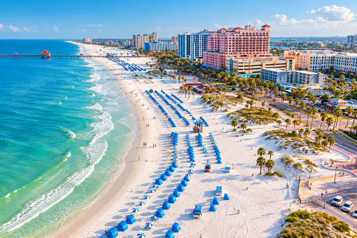
Clearwater reaches from the mainland bluff above Clearwater Harbor out to the Gulf beaches, and it is the county seat of Pinellas. This guide walks through its historic district, its island and beach neighborhoods, the flood and evacuation tools to use for any address, and the causeways that tie it together.
Location & character
According to the city’s history, Fort Harrison stood on a bluff above Clearwater Harbor around 1835, in what is now the Harbor Oaks area. The town was first incorporated in 1891 and reincorporated as a city on May 27, 1915.
Pinellas split from Hillsborough County in 1912, and in 1915 a bridge across Clearwater Harbor reached Clearwater Beach. Henry Plant’s Belleview Biltmore hotel, opened in 1897, helped turn the area into a resort destination.
Today the city takes in the mainland around downtown, Clearwater Beach, Island Estates and its part of Sand Key, tied together by the Memorial Causeway. A Clearwater mailing address can also belong to an unincorporated pocket such as Feather Sound, so confirm the jurisdiction with the Pinellas County Property Appraiser.
Neighborhoods & home types
Clearwater’s homes range from early-twentieth-century houses on the harbor bluff to island streets and beachfront condominium buildings.
The Harbor Oaks Residential District was listed on the National Register on March 15, 1988. It is bounded by Druid Road, South Fort Harrison Avenue, Lotus Path and Clearwater Harbor.
Developer Dean Alvord opened Harbor Oaks in 1914, and it was largely built out by 1930, with Mediterranean Revival, Colonial Revival, Tudor Revival, Mission and Bungalow homes.
The island east of Clearwater Beach and north of the Memorial Causeway has single-family homes, condominiums and businesses. If a canal lot or a private dock is on your list, confirm dock rights and water depth for each property.
Barrier-island areas on the Gulf with beachfront resorts and condominium buildings. For a condo, ask the association for its budget, reserves, insurance and recent inspection reports.
Downtown sits on the mainland along Clearwater Harbor, home to Coachman Park and The BayCare Sound amphitheater.
Waterfront living
Pier 60 Park on Clearwater Beach has a 1,080-foot fishing pier, a playground and lifeguards, and it hosts the nightly Sunsets at Pier 60 event.
On Sand Key, Pinellas County’s 95-acre Sand Key Park, at 1060 Gulf Blvd., has a beach, trails, picnic areas, a playground, a dog park and seasonal lifeguards.
Just to the north, in Dunedin rather than Clearwater, Caladesi Island State Park is reached by ferry from Honeymoon Island or by private boat.
Flood zones & insurance
Use the Pinellas County Flood Map Service Center (“My Flood Risk”) for the flood zone and the county’s Know Your Zone tool for the evacuation zone. They answer different questions, and a home can rank low on one and high on the other.
The City of Clearwater’s floodplain management pages on myclearwater.com add an interactive map with flood and elevation data for individual properties, including elevation certificates where they are available.
FEMA has released preliminary flood maps for the Alligator Creek watershed in Clearwater that would move some buildings into the special flood hazard area and take others out. Until the new maps take effect, ask the city’s floodplain staff whether a property is affected.
During Hurricane Helene, the National Weather Service measured a peak of 6.67 feet above mean higher high water at Clearwater Beach, above the previous record of 4.02 feet from the 1993 Storm of the Century. Ahead of Hurricane Milton, the Pinellas Sheriff restricted and then closed access to the barrier islands from Sand Key south to Pass-a-Grille, a reminder that island homes can be cut off during a storm.
Getting around
Connects downtown Clearwater with Clearwater Beach and Island Estates.
Crosses Old Tampa Bay toward Tampa and Tampa International Airport.
The main north-south highway through the city’s mainland.
The county’s airport lies southeast of Clearwater in mid-Pinellas.
A ferry has run between downtown and the Clearwater Marina on the beach. Check current routes and schedules before you rely on it.
Local government & useful links
The city’s permit pages explain what needs a permit; larger projects also need a Notice of Commencement recorded with the Pinellas Clerk, and the city lists the thresholds.
City permitsApply for and look up city permits online.
Accela portalOwnership, exemptions and jurisdiction for any Pinellas parcel.
pcpao.govUse the Pinellas County Schools locator for the address itself; zones can change.
School LocatorThe Clearwater Police Department runs a neighborhood-watch group page for Island Estates.
Clearwater PD groupHome Search
Each link opens Home Search with Clearwater already selected. What you see there comes from the live search and changes as homes are listed and sold.
Ekin can help you compare neighborhoods, set up a search that fits how you want to live, and work through flood, HOA, CDD and permit questions for the homes on your list.
Mucahit “Muca” Ekin | Real Estate Advisor | LPT Realty
Sources
Official sources used for this guide. Last reviewed: October 17, 2026.
This guide is general information from public sources, not legal, tax or insurance advice, and it says nothing about any particular property. Not every detail applies to every street: confirm with the city or county, the HOA or CDD, and your inspector before you rely on it.